![](/images/other/stat-length.png)
![Tocht Te voet Hollersbach im Pinzgau - Bachlehrweg Hollersbach (kurze Wanderung) - Photo](https://media.geolcdn.com/t/1900/400/aed1fcfd-fa4c-4066-b8e3-7a434322b071.jpeg&format=pjpeg&maxdim=2)
Bachlehrweg Hollersbach (kurze Wanderung)
SityTrail - itinéraires balisés pédestres
Tous les sentiers balisés d’Europe GUIDE+
![Lengte](/images/other/stat-length.png)
Lengte
4,7 km
![Max. hoogte](https://static1.geolcdn.com/siteimages/upload/files/1508320355ic_sort_altitude_max_24dp.png)
Max. hoogte
1088 m
![Positief hoogteverschil](https://static1.geolcdn.com/siteimages/upload/files/1508320355ic_sort_den_pos_24dp.png)
Positief hoogteverschil
250 m
![Km-Effort](/images/other/stat-length.png)
Km-Effort
7,3 km
![Min. hoogte](https://static1.geolcdn.com/siteimages/upload/files/1508320355ic_sort_altitude_min_24dp.png)
Min. hoogte
873 m
![Negatief hoogteverschil](https://static1.geolcdn.com/siteimages/upload/files/1508320355ic_sort_den_neg_24dp.png)
Negatief hoogteverschil
43 m
![Boucle](https://static1.geolcdn.com/siteimages/upload/files/16400158638029165_repeat_loop_refresh_sync_direction_icon.png)
Boucle
Neen
Markering
Datum van aanmaak :
2022-02-16 16:22:09.96
Laatste wijziging :
2022-03-03 06:30:54.165
![Te voet](https://static1.geolcdn.com/sitytour/trail-icons/100.png)
1h40
Moeilijkheid : Gemakkelijk
![Scan deze QR-code om de tocht te openen in de SityTrail-applicatie](https://capi.geolives.com/qq0zvz2zws4bq2lad0pu/sitytour/trails/3126773/qr.png?size=200)
Gratisgps-wandelapplicatie
Over ons
Tocht Te voet van 4,7 km beschikbaar op Salzburg, Bezirk Zell am See, Hollersbach im Pinzgau. Deze tocht wordt voorgesteld door SityTrail - itinéraires balisés pédestres.
Beschrijving
Trail created by Nationalpark Hohe Tauern.
Plaatsbepaling
Land:
Austria
Regio :
Salzburg
Departement/Provincie :
Bezirk Zell am See
Gemeente :
Hollersbach im Pinzgau
Locatie:
Unknown
Vertrek:(Dec)
Vertrek:(UTM)
304400 ; 5238117 (33T) N.
Opmerkingen
Wandeltochten in de omgeving
![Tocht Te voet Hollersbach im Pinzgau - Bienenlehrpfad - Photo](https://media.geolcdn.com/t/375/260/6b0b1b2d-5e2f-4e71-ac0e-cccde0b40ed6.jpeg&format=jpg&maxdim=2)
![Te voet Te voet](https://static1.geolcdn.com/sitytour/trail-icons/100.png)
Bienenlehrpfad
Te voet
Gemakkelijk
Hollersbach im Pinzgau,
Salzburg,
Bezirk Zell am See,
Austria
![](/images/other/stat-length.png)
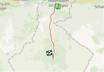
4,5 km | 8,6 km-effort
1h 57min
![](https://static1.geolcdn.com/siteimages/upload/files/16400158638029165_repeat_loop_refresh_sync_direction_icon.png)
Neen
![Tocht Te voet Hollersbach im Pinzgau - Naturlehrpfad - Photo](https://media.geolcdn.com/t/375/260/4e1fa551-f9d7-4fb3-8428-992b709f463a.jpeg&format=jpg&maxdim=2)
![Te voet Te voet](https://static1.geolcdn.com/sitytour/trail-icons/100.png)
Naturlehrpfad
Te voet
Gemakkelijk
Hollersbach im Pinzgau,
Salzburg,
Bezirk Zell am See,
Austria
![](/images/other/stat-length.png)
3,2 km | 6,1 km-effort
1h 23min
![](https://static1.geolcdn.com/siteimages/upload/files/16400158638029165_repeat_loop_refresh_sync_direction_icon.png)
Neen
![Tocht Te voet Hollersbach im Pinzgau - Wanderweg Berghof Pihapper - Photo](https://media.geolcdn.com/t/375/260/ext.jpg?maxdim=2&url=https%3A%2F%2Fstatic1.geolcdn.com%2Fsiteimages%2Fupload%2Ffiles%2F1545311037marcheuse_200dpi.jpg)
![Te voet Te voet](https://static1.geolcdn.com/sitytour/trail-icons/100.png)
Wanderweg Berghof Pihapper
Te voet
Gemakkelijk
Hollersbach im Pinzgau,
Salzburg,
Bezirk Zell am See,
Austria
![](/images/other/stat-length.png)
6,2 km | 19,1 km-effort
4h 20min
![](https://static1.geolcdn.com/siteimages/upload/files/16400158638029165_repeat_loop_refresh_sync_direction_icon.png)
Neen